


Metar-Taf is a comprehensive weather application designed specifically for aviation enthusiasts and professionals. This app provides visualized METAR and TAF weather information for airports worldwide, offering users an easy-to-understand, colorful interface with concise summaries of essential aviation weather data. Key features include crosswind calculations, flight rule categorization (VFR, MVFR, IFR, LIFR), and text-to-speech functionality for decoded METAR reports.
In addition to current weather conditions, Metar-Taf offers detailed forecasts through its TAF feature, breaking down terminal aerodrome forecasts hour by hour. Users can track their favorite stations, access observations near their location, and search airports via ICAO code or name. The app also includes historical weather graphs, airport information, customizable units, and automatic data saving for offline use.
This versatile tool is invaluable for pilots, dispatchers, and aviation meteorologists who need reliable, real-time weather information at their fingertips. Its comprehensive feature set and user-friendly design make it an essential companion for both professional and recreational flying activities.
Metar-Taf stands out with its extensive feature set tailored for aviation weather analysis. The app's METAR visualization presents complex weather data through intuitive color metrics and standardized weather symbols, making it accessible even to non-aviation professionals. The unique crosswind calculation feature combines METAR data with runway information, providing crucial safety information for pilots.
The TAF breakdown feature presents terminal forecasts in an hourly table format, including additional valuable information such as sunrise/sunset times and temperature extremes. The app's tracking capabilities allow users to maintain a list of favorite stations, access location-based observations, and utilize an interactive map with weather codes. Its historical weather trend analysis and comprehensive airport information database further enhance its value.
What sets Metar-Taf apart is its exceptional customization options. Users can adjust measurement units across various parameters, including speed, altitude, visibility, temperature, and air pressure. The app automatically converts times to local time zones and calculates sunrise/sunset based on airport coordinates. With support for multiple languages and automatic data caching for offline use, Metar-Taf delivers both flexibility and reliability in aviation weather reporting.
Accurate weather forecasting is crucial for aviation safety and planning. Metar-Taf provides reliable METAR and TAF data for airports worldwide, ensuring pilots and aviation professionals have trustworthy information at their fingertips.
The app visualizes weather data through easy-to-understand colorful metrics and symbols, similar to non-aviation weather reports. This includes significant weather conditions and cloud formations, making it accessible even to those not specialized in aviation meteorology.
With features like crosswind calculations, flight rule categorization, and text-to-speech functionality, users can decode and listen to METAR reports while multitasking. The breakdown of TAF forecasts into hourly tables with additional data such as sunrise, sunset, and temperature extremes further enhances the precision and utility of the provided forecasts.
Understanding weather patterns over time and space is essential for effective flight planning. Metar-Taf excels in providing comprehensive temporal and spatial forecast ranges, empowering users with extensive weather trend analysis.
The app offers graphs displaying weather trends for today and yesterday, covering critical parameters such as temperature, visibility, wind speed, and QNH. This allows users to identify patterns and make informed decisions based on historical and current data.
Users can access METAR history for recent hours and find more information on the website. By adding favorite stations, they can track weather conditions at a glance and locate nearby observations, enhancing situational awareness across different geographical locations.
User-friendly interface
Comprehensive weather data
Offline functionality
Customizable units
Global airport coverage
Premium features locked
Occasional data delays
Advanced aviation focus
Learning curve present
Some features require payment

Weather for Indiana, Kentucky and Ohio
 4.90
4.90
Live weather radar, widgets & forecasts. Track rain, storms & temperature.
4.20
Global weather forecast, powered by layered radar & hourly weather updates
4.10
3D Animation Weather Icon
4.00
Accurate, beautiful weather with landscapes depicting weather, sky, season.
4.50
Track lightning strikes with our thunderstorms map, radar and lightning alarm.
4.70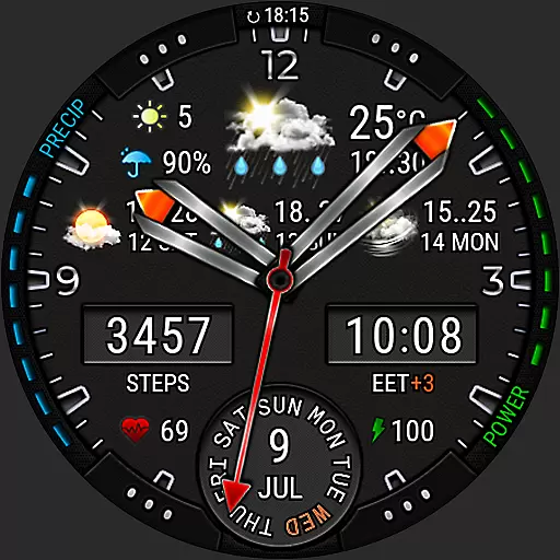
Analog Weather Watch Face for Wear OS 5+
4.10
Magnetic Compass meets smart tech: Get directions and weather alerts seamlessly
3.30
Weather Forecast, Trending News, Hurricane & Storm Tracker, Alerts & Live Radar.
4.80
Live Weather Forecast app with acu weather radar, weather alert & weather widget
4.80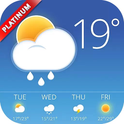
Nuts Weather, your ideal choice for knowing weather forecast & weather radar
4.70
Thermometer shows indoor and outdoor temperature
4.70
Check room temperature with this indoor thermometer. thermostat & hydrometer
4.70
The weather channel, tiempo weather forecast, weather radar & weather map
4.70
Your ultimate app for real-time weather information!
4.70
Accurate Thermometer: indoor & outdoor temperature, humidity, pressure, and wind
4.50
Advanced weather toolkit, providing detailed weather information for any season!
3.50
Most precise & accurate compass app give true North South East West directions.
3.00
Retro TV-style digital watch face with weather, heart rate, steps & events!
4.5

User Reviews